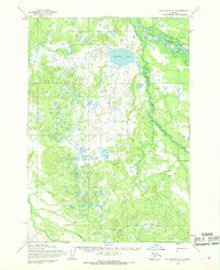
1954 Map of Sleetmute B-1
USGS Topo · Published 1968About this map
Stony River and its winding tributary, the Stink River, dominate this interior Alaska landscape as mapped in the mid-1950s. The region is defined by a dense network of muskeg, small ponds, and the significant Tishimna Lake, illustrating the complex drainage patterns of the Kuskokwim River basin. This era of mapping relied heavily on photogrammetric methods from aerial surveys conducted between 1953 and 1957 by the Army Map Service. A solitary Winter Trail cuts through the southwestern terrain, marking one of the few established overland routes through the wilderness. To the north, Etatuti Creek feeds into the low-lying wetlands, representing a landscape largely untouched by permanent settlement at the time of the survey, where land lines remained unsurveyed and unmarked.
Find a feature on this map
5 named features on this map. Tap any name to fly to it.
Don’t see what you’re looking for? This feature index may not catch every label — zoom into the map to look around manually.
Map Details
Editions of this 1954 Sleetmute B-1 Map
This is the sole edition of this map. No revisions or reprints were ever made.
Other maps of this area

1950 · Sleetmute
USGS Topo · 1:250,000

1951 · Lime Hills
USGS Topo · 1:250,000

1954 · Sleetmute C-2
USGS Topo · 1:63,360

1954 · Sleetmute C-1
USGS Topo · 1:63,360

1954 · Lime Hills A-8
USGS Topo · 1:63,360

1954 · Sleetmute
USGS Topo · 1:250,000

1954 · Sleetmute B-2
USGS Topo · 1:63,360
1954 · Sleetmute A-1
USGS Topo · 1:63,360
1954 · Sleetmute A-2
USGS Topo · 1:63,360

1954 · Lime Hills B-8
USGS Topo · 1:63,360