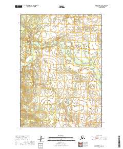
2019 Map of Sleetmute B-2 SE
USGS Topo · Published 2019About this map
Bethel Census Area's interior landscape is documented here through a focus on the Public Land Survey System, highlighting the legal and physical divisions of this remote terrain. The territory is defined by several major township and range blocks, including T14n R40w, T15n R40w, and T14n R41w, which provide the underlying grid for land management and mineral claims in this part of Alaska. The absence of named settlements, roads, or localized landmarks in this 2019 survey emphasizes the raw character of the region. Researchers can trace the boundaries of T15n R41w, T13n R41w, and T13n R40w across the undulating contour lines of the National Elevation Dataset, illustrating how the US Topo series catalogs even the most isolated sections of the American wilderness.
Find a feature on this map
6 named features on this map. Tap any name to fly to it.
Don’t see what you’re looking for? This feature index may not catch every label — zoom into the map to look around manually.
Map Details
Editions of this 2019 Sleetmute B-2 SE Map
This is the sole edition of this map. No revisions or reprints were ever made.
Other maps of this area

1950 · Sleetmute
USGS Topo · 1:250,000

1954 · Sleetmute
USGS Topo · 1:250,000

1954 · Sleetmute B-2
USGS Topo · 1:63,360
1954 · Sleetmute A-1
USGS Topo · 1:63,360
1954 · Sleetmute A-2
USGS Topo · 1:63,360
1954 · Sleetmute B-1
USGS Topo · 1:63,360
2019 · Sleetmute A-1 NW
USGS Topo · 1:25,000
2019 · Sleetmute A-2 NW
USGS Topo · 1:25,000
2019 · Sleetmute B-1 NW
USGS Topo · 1:25,000
2019 · Sleetmute A-2 NE
USGS Topo · 1:25,000