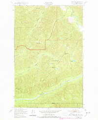
1950 Map of Slide Peak
USGS Topo · Published 1978About this map
The Bogachiel River and North Fork Bogachiel River carve deep drainages through this wilderness landscape on the border of Clallam and Jefferson counties. Originally surveyed in 1950, this map documents a network of high-elevation trails and remote backcountry waypoints such as Hyak Shelter and Twentyone mile Shelter. The terrain is defined by prominent summits including Slide Peak, Misery Peak, and Sugarloaf Mountain, as well as distinctive geographic features like the Sore Thumb to the north.
Find a feature on this map
26 named features on this map. Tap any name to fly to it.
Don’t see what you’re looking for? This feature index may not catch every label — zoom into the map to look around manually.
Map Details
Editions of this 1950 Slide Peak Map
4 editions found
Other maps of this area

1918 · Lake Crescent
USGS Topo · 1:62,500

1922 · Pysht
USGS Topo · 1:62,500

1922 · Lake Crescent
USGS Topo · 1:62,500

1939 · Mount Tom
USGS Topo · 1:62,500

1942 · Pysht
USGS Topo · 1:62,500

1943 · Spruce Mountain
USGS Topo · 1:62,500

1943 · Copalis Beach
USGS Topo · 1:250,000

1950 · Mount Muller
USGS Topo · 1:24,000

1950 · Lake Crescent
USGS Topo · 1:24,000

1950 · Slide Peak
USGS Topo · 1:24,000