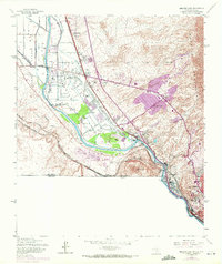
1955 Map of Smeltertown
USGS Topo · Published 1972About this map
The Rio Grande carves a path through this borderland landscape where El Paso meets the international boundary of Chihuahua, Mexico. This 1955 survey, updated with 1967 aerial photography, documents the industrial and cultural concentration of Smeltertown and Courchesne near the river's bend. The complex network of water management is visible through the Montoya Drain and Nemexas Drain, supporting the agricultural zones of Montoya while the rising slopes of the Franklin Mountains and Sierra de Cristo Rey define the eastern and western horizons.
Find a feature on this map
45 named features on this map. Tap any name to fly to it.
Don’t see what you’re looking for? This feature index may not catch every label — zoom into the map to look around manually.
Map Details
Editions of this 1955 Smeltertown Map
5 editions found

Other maps of this area

1896 · El Paso
USGS Topo · 1:125,000

1908 · El Paso
USGS Topo · 1:125,000

1917 · Canutillo
USGS Topo · 1:62,500

1919 · Canutillo
USGS Topo · 1:62,500

1939 · Ysleta
USGS Topo · 1:62,500

1941 · El Paso
USGS Topo · 1:31,680

1941 · Ysleta
USGS Topo · 1:62,500

1942 · Fort Bliss
USGS Topo · 1:62,500

1943 · El Paso
USGS Topo · 1:31,680

1945 · Ysleta
USGS Topo · 1:62,500