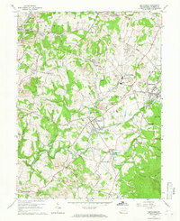
1964 Map of Smithfield
USGS Topo · Published 1966About this map
Industrial activity and rural settlement define this 1964 survey of southwestern Fayette County. The extraction economy of the era is evident in the numerous Strip Mine operations and Gas Well sites that dot the landscape between Smithfield and Fairchance. Heavy industry is concentrated near the Baltimore and Ohio Railroad, where Coke Ovens and a Tipple are marked alongside the rail lines.
Find a feature on this map
82 named features on this map. Tap any name to fly to it.
Don’t see what you’re looking for? This feature index may not catch every label — zoom into the map to look around manually.
Map Details
Editions of this 1964 Smithfield Map
Other maps of this area

1900 · Uniontown
USGS Topo · 1:62,500

1900 · Masontown
USGS Topo · 1:62,500

1902 · Morgantown
USGS Topo · 1:62,500

1903 · Masontown
USGS Topo · 1:62,500

1904 · Bruceton
USGS Topo · 1:62,500

1925 · Morgantown
USGS Topo · 1:62,500

1926 · Bruceton
USGS Topo · 1:62,500

1931 · Uniontown
USGS Topo · 1:62,500

1931 · Masontown
USGS Topo · 1:62,500

1931 · Bruceton Mills
USGS Topo · 1:62,500