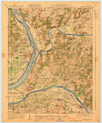
1929 Map of Smithland
USGS Topo · Published 1929About this map
The Smithland area serves as a critical junction for three major American waterways, where the Cumberland River and Tennessee River converge into the Ohio River. This 1920s survey captures the region's intense river-based economy, evidenced by numerous historical river access points such as Lemmon Landing, Haddock Ferry, and Cooper Landing. The landscape is dotted with early 20th-century rural infrastructure, from the Salty Point Sch to the Illinois Central railroad corridor passing through Calvert City. Mining activity is prominent in the northern reaches of the quadrangle, with the Klondike Mine and Royal Mine located near Burna. Further west, the Illinois shoreline reveals archaeological and natural landmarks like Kincaid Mounds Lake and Beaverdam Lake, contrasting with the more industrial and transit-focused Kentucky side of the rivers.
Find a feature on this map
101 named features on this map. Tap any name to fly to it.
Don’t see what you’re looking for? This feature index may not catch every label — zoom into the map to look around manually.
Map Details
Editions of this 1929 Smithland Map
3 editions found
Other maps of this area

1916 · Fords Ferry
USGS Topo · 1:62,500

1916 · Golconda
USGS Topo · 1:62,500

1917 · Brownfield
USGS Topo · 1:62,500

1920 · Goloonda
USGS Topo · 1:48,000

1921 · Fords Ferry
USGS Topo · 1:48,000

1921 · Golconda
USGS Topo · 1:62,500

1925 · Cave In Rock
USGS Topo · 1:62,500

1926 · Paducah
USGS Topo · 1:62,500

1928 · Eddyville
USGS Topo · 1:48,000

1929 · Smithland
USGS Topo · 1:62,500