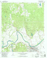
1982 Map of Smithville
USGS Topo · Published 1982About this map
The Colorado River carves a deep path through Bastrop County, defining a landscape of agricultural lowlands and wooded uplands in the early 1980s. The town of Smithville sits along the southern bank, where the M-K-T railroad and the Kansas Missouri Texas line intersect, anchoring the regional economy near Gazley. Away from the river, the terrain rises into the protected timberlands of Bastrop State Park and Buescher State Park, connected by the historic Gotier Trace. This survey reveals the transition between riverside farming in David Bottom and the upland woods. Local heritage is preserved in numerous rural landmarks, including the Antioch Ch and family burial grounds such as Claiborne Cem and Crafts Prairie Cem. The presence of the University of Texas Research Center and the Municipal Airport indicates the modernization of this traditional river community.
Find a feature on this map
46 named features on this map. Tap any name to fly to it.
Don’t see what you’re looking for? This feature index may not catch every label — zoom into the map to look around manually.
Map Details
Editions of this 1982 Smithville Map
2 editions found
Other maps of this area

1885 · Bastrop
USGS Topo · 1:125,000

1893 · Bastrop
USGS Topo · 1:125,000

1901 · Flatonia
USGS Topo · 1:125,000

1904 · Bastrop
USGS Topo · 1:125,000

1948 · Smithville
USGS Topo · 1:62,500

1948 · Bastrop
USGS Topo · 1:62,500

1950 · Bastrop
USGS Topo · 1:62,500

1950 · Smithville
USGS Topo · 1:62,500

1953 · Seguin
USGS Topo · 1:250,000

1954 · Austin
USGS Topo · 1:250,000