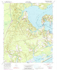
1952 Map of Sneads Ferry
USGS Topo · Published 1992About this map
Camp Lejeune Military Reservation dominates the landscape of this 1952 coastal survey, where the terrestrial environment of Onslow County meets the complex waters of the New River and Stump Sound. The map documents a maritime-dependent community characterized by numerous small landings, including Stones Landing, Fulcher Landing, and Sandford Landing, which served as vital access points before the modern era of inland transport. These landings reflect the traditional economy of the North Carolina coast, which was then transitioning as the military footprint expanded.
Find a feature on this map
44 named features on this map. Tap any name to fly to it.
Don’t see what you’re looking for? This feature index may not catch every label — zoom into the map to look around manually.
Map Details
Editions of this 1952 Sneads Ferry Map
5 editions found
Other maps of this area

1942 · Spicer Bay
USGS Topo · 1:62,500

1942 · Topsail
USGS Topo · 1:62,500

1948 · Maple Hill
USGS Topo · 1:62,500

1948 · Topsail
USGS Topo · 1:62,500

1948 · New River
USGS Topo · 1:62,500

1952 · Camp Lejeune
USGS Topo · 1:24,000

1952 · Jacksonville South
USGS Topo · 1:24,000

1952 · Spicer Bay
USGS Topo · 1:24,000

1952 · New River Inlet
USGS Topo · 1:24,000

1952 · Sneads Ferry
USGS Topo · 1:24,000
Featured Places
- Sneads Ferry, NC
- Holly Ridge, NC
- North Topsail Beach, NC
- Marine Corps Base Camp Lejeune, NC
- Fulcher Landing, NC