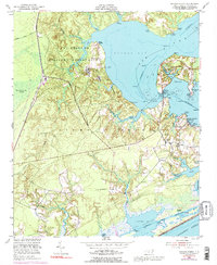
1952 Map of Sneads Ferry
USGS Topo · Published 1992About this map
Camp Lejeune Military Reservation dominates the northern landscape of this coastal Onslow County area, where the New River opens into the broad waters of Stones Bay. This 1952 survey, photo-revised in the early 1970s, documents the critical transition between military training grounds and the commercial fishing and maritime life around Sneads Ferry. The map captures the intricate shoreline of Stump Sound and Alligator Bay, showing the importance of the Intracoastal Waterway and the Seaboard Coast Line for regional transport. Local social history is grounded in the numerous landings and rural churches, including Topps Ch, Little Zion Ch, and Carrells Chapel. From the Sneads Ferry Bridge to the small community at Dixon, the map provides a detailed record of coastal North Carolina during a period of significant military and infrastructure growth.
Find a feature on this map
45 named features on this map. Tap any name to fly to it.
Don’t see what you’re looking for? This feature index may not catch every label — zoom into the map to look around manually.
Map Details
Editions of this 1952 Sneads Ferry Map
5 editions found
Other maps of this area

1942 · Spicer Bay
USGS Topo · 1:62,500

1942 · Topsail
USGS Topo · 1:62,500

1948 · Maple Hill
USGS Topo · 1:62,500

1948 · Topsail
USGS Topo · 1:62,500

1948 · New River
USGS Topo · 1:62,500

1952 · Camp Lejeune
USGS Topo · 1:24,000

1952 · Jacksonville South
USGS Topo · 1:24,000

1952 · Spicer Bay
USGS Topo · 1:24,000

1952 · New River Inlet
USGS Topo · 1:24,000

1952 · Sneads Ferry
USGS Topo · 1:24,000
Featured Places
- Sneads Ferry, NC
- Holly Ridge, NC
- North Topsail Beach, NC
- Marine Corps Base Camp Lejeune, NC
- Fulcher Landing, NC