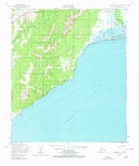
1950 Map of Solomon C-1
USGS Topo · Published 1980About this map
The coastal interface of Norton Bay and the southern Darby Mountains is the focus of this mid-century survey. Most of the land shown is part of the Norton Bay Native Reservation, featuring a terrain of steep peaks like Mt Kwiniuk and coastal features such as Marble Cliffs. Small settlements and seasonal camps dot the shoreline, notably the Moses Point Fishing Village and Elim, while Walla Walla sits further south along the coast.
Find a feature on this map
19 named features on this map. Tap any name to fly to it.
Don’t see what you’re looking for? This feature index may not catch every label — zoom into the map to look around manually.
Map Details
Editions of this 1950 Solomon C-1 Map
4 editions found
Other maps of this area

1948 · Norton Bay
USGS Topo · 1:250,000

1950 · Norton Bay D-6
USGS Topo · 1:63,360

1950 · Solomon B-2
USGS Topo · 1:63,360

1950 · Solomon D-2
USGS Topo · 1:63,360

1950 · Solomon C-2
USGS Topo · 1:63,360

1950 · Solomon C-1
USGS Topo · 1:63,360

1950 · Norton Bay C-6
USGS Topo · 1:63,360

1950 · Solomon D-1
USGS Topo · 1:63,360

1950 · Solomon
USGS Topo · 1:250,000

1951 · Solomon
USGS Topo · 1:250,000