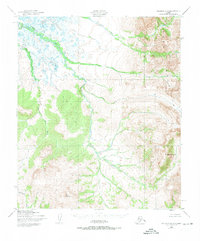
1950 Map of Solomon D-2
USGS Topo · Published 1973About this map
The Darby Mountains dominate the eastern landscape of this Seward Peninsula region, where sharp relief meets the complex drainage systems of the Rathlatulik River. This terrain, documented by the Army Corps of Engineers and Geological Survey using 1950 aerial photography, showcases a wilderness defined by its watercourses and prominent peaks. High points like Mt Arathlatuluk and Mt Kachauik overlook a network of seasonal and perennial flows, including Omilak Creek and the Kachauik River. The absence of roads or trails on this sheet highlights the remote character of the interior during the mid-twentieth century, as the landscape remained largely unsurveyed and unmarked on the ground. Water is the primary structural element here, with features such as Dry Canyon Creek and Burnt Creek carving through the steep elevation changes of the Darby range.
Find a feature on this map
8 named features on this map. Tap any name to fly to it.
Don’t see what you’re looking for? This feature index may not catch every label — zoom into the map to look around manually.
Map Details
Editions of this 1950 Solomon D-2 Map
3 editions found
Other maps of this area

1950 · Bendeleben A-3
USGS Topo · 1:63,360

1950 · Bendeleben A-2
USGS Topo · 1:63,360

1950 · Bendeleben A-1
USGS Topo · 1:63,360

1950 · Solomon D-2
USGS Topo · 1:63,360

1950 · Solomon C-2
USGS Topo · 1:63,360

1950 · Bendeleben
USGS Topo · 1:250,000

1950 · Solomon C-1
USGS Topo · 1:63,360

1950 · Solomon D-1
USGS Topo · 1:63,360

1950 · Solomon D-3
USGS Topo · 1:63,360

1950 · Solomon
USGS Topo · 1:250,000