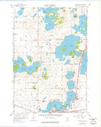
1958 Map of Solomon Lake
USGS Topo · Published 1977About this map
Willmar anchors the southern edge of this West Central Minnesota landscape, where the city’s early infrastructure meets the expansive glacial lake systems of Kandiyohi County. The map details a transition from the urban grid and industrial facilities like the Willmar State Hospital and Sewage Disposal plant to a rural patchwork of township sections. Transportation is dominated by the Great Northern railroad corridors, which cut through the lakeside terrain to support the region’s agricultural economy.
Find a feature on this map
52 named features on this map. Tap any name to fly to it.
Don’t see what you’re looking for? This feature index may not catch every label — zoom into the map to look around manually.
Map Details
Editions of this 1958 Solomon Lake Map
3 editions found
Other maps of this area

1953 · Saint Cloud
USGS Topo · 1:250,000

1956 · Atwater
USGS Topo · 1:62,500

1957 · Saint Cloud
USGS Topo · 1:250,000

1958 · Saint Cloud
USGS Topo · 1:250,000

1958 · Raymond
USGS Topo · 1:24,000

1958 · Pennock
USGS Topo · 1:24,000

1958 · Willmar
USGS Topo · 1:24,000

1958 · Solomon Lake
USGS Topo · 1:24,000

1967 · Mount Tom
USGS Topo · 1:24,000

1967 · Sunburg
USGS Topo · 1:24,000