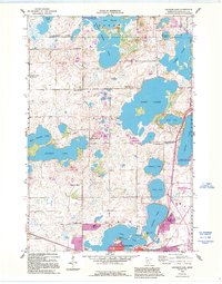
1958 Map of Solomon Lake
USGS Topo · Published 1995About this map
The city of Willmar anchors the southern edge of this West Central Minnesota landscape, characterized by a dense concentration of glacial lakes and wetlands. Originally field checked in the late 1950s with revisions through the early 1990s, the map documents the growth of the community around Foot Lake and Willmar Lake, including the campus of the Willmar State Hospital. The surrounding rural townships of Dovre and Mamre are dotted with numbered schoolhouses like School No 761 and local centers of worship such as Solomon Lake Ch. Several small burial grounds, including Lunby Cem and Endresen Cem, provide specific points of interest for genealogists tracking early settlers. Conservation efforts are evident in the numerous protected areas like the Ringo Nest State Wildlife Management Area, which preserves the habitat around Ringo Lake and its neighboring sloughs.
Find a feature on this map
47 named features on this map. Tap any name to fly to it.
Don’t see what you’re looking for? This feature index may not catch every label — zoom into the map to look around manually.
Map Details
Editions of this 1958 Solomon Lake Map
3 editions found
Other maps of this area

1953 · Saint Cloud
USGS Topo · 1:250,000

1956 · Atwater
USGS Topo · 1:62,500

1957 · Saint Cloud
USGS Topo · 1:250,000

1958 · Saint Cloud
USGS Topo · 1:250,000

1958 · Raymond
USGS Topo · 1:24,000

1958 · Pennock
USGS Topo · 1:24,000

1958 · Willmar
USGS Topo · 1:24,000

1958 · Solomon Lake
USGS Topo · 1:24,000

1967 · Mount Tom
USGS Topo · 1:24,000

1967 · Sunburg
USGS Topo · 1:24,000