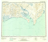
1951 Map of Solomon
USGS Topo · Published 1954About this map
The Seward Peninsula coastline and the surrounding mountain ranges define this mid-century portrait of Alaska's coastal interior. The landscape is anchored by the Niukluk River and Fish River systems, which flow through a region marked by early 20th-century mining activity and established coastal outposts. Coastal life is centered on Golovnin Lagoon and Golovnin Bay, where the settlements of Golovin and White Mountain served as critical hubs for transport and communication.
Find a feature on this map
49 named features on this map. Tap any name to fly to it.
Don’t see what you’re looking for? This feature index may not catch every label — zoom into the map to look around manually.
Map Details
Editions of this 1951 Solomon Map
3 editions found

Other maps of this area

1907 · Casadepaga
USGS Topo · 1:62,500

1907 · Solomon
USGS Topo · 1:62,500

1948 · Norton Bay
USGS Topo · 1:250,000

1950 · Bendeleben A-6
USGS Topo · 1:63,360

1950 · Bendeleben A-4
USGS Topo · 1:63,360

1950 · Bendeleben A-5
USGS Topo · 1:63,360

1950 · Bendeleben A-3
USGS Topo · 1:63,360

1950 · Bendeleben A-2
USGS Topo · 1:63,360

1950 · Bendeleben A-1
USGS Topo · 1:63,360

1950 · Solomon B-3
USGS Topo · 1:63,360