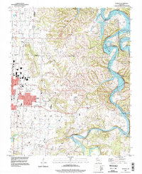
1994 Map of Sonora
USGS Topo · Published 1998About this map
White River and the winding reaches of Beaver Lake dominate this mid-century survey of the terrain east of Springdale. The landscape is a mix of agricultural uplands and sharp relief, punctuated by heights like Fitzgerald Mountain and Price Mountain. Evidence of early community centers is preserved in the distribution of rural institutions, such as Southern Grove Ch and Accident Sch, which served the scattered residents before the expansion of nearby urban centers. The mapping of Pleasure Heights near the river bluffs indicates the emerging recreational and residential appeal of the waterfront. Modern infrastructure is represented by the Springdale Municipal Airport and the corridor for Route 412, while older landmarks like the Phillips Cem and Davis Cem provide essential data points for tracing family lineages across these Ozark foothills.
Find a feature on this map
43 named features on this map. Tap any name to fly to it.
Don’t see what you’re looking for? This feature index may not catch every label — zoom into the map to look around manually.
Map Details
Editions of this 1994 Sonora Map
This is the sole edition of this map. No revisions or reprints were ever made.
Other maps of this area

1899 · Fayetteville
USGS Topo · 1:125,000

1900 · Eureka Springs
USGS Topo · 1:125,000

1901 · Eureka Springs
USGS Topo · 1:125,000

1901 · Fayetteville
USGS Topo · 1:125,000

1904 · Fayetteville
USGS Topo · 1:125,000

1945 · Harrison
USGS Topo · 1:250,000

1949 · Harrison
USGS Topo · 1:250,000

1954 · Harrison
USGS Topo · 1:250,000

1954 · Tulsa
USGS Topo · 1:250,000

1957 · War Eagle
USGS Topo · 1:24,000