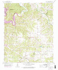
1958 Map of Spring Valley
USGS Topo · Published 1977About this map
Spring Valley and the surrounding hill country of the Benton and Washington county lines appear here during a period of significant hydrological change. The mapping includes purple photorevisions from 1976, most notably documenting the presence of Beaver Lake where the White River and War Eagle Creek meet. This transition from a riverine landscape to a reservoir system is captured alongside established rural infrastructure, including several family and community landmarks such as Austin Cem, Mayfield Cem, and Johnson Cem.
Find a feature on this map
44 named features on this map. Tap any name to fly to it.
Don’t see what you’re looking for? This feature index may not catch every label — zoom into the map to look around manually.
Map Details
Editions of this 1958 Spring Valley Map
3 editions found
Other maps of this area

1899 · Fayetteville
USGS Topo · 1:125,000

1900 · Eureka Springs
USGS Topo · 1:125,000

1901 · Eureka Springs
USGS Topo · 1:125,000

1901 · Fayetteville
USGS Topo · 1:125,000

1904 · Fayetteville
USGS Topo · 1:125,000

1945 · Harrison
USGS Topo · 1:250,000

1949 · Harrison
USGS Topo · 1:250,000

1954 · Harrison
USGS Topo · 1:250,000

1954 · Tulsa
USGS Topo · 1:250,000

1957 · Mundell
USGS Topo · 1:24,000