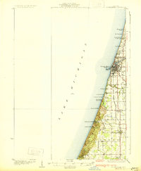
1930 Map of South Haven
USGS Topo · Published 1930About this map
Lake Michigan dominates the western edge of this 1920s-era survey, where high dunes and coastal bluffs meet the shoreline. The bustling port of South Haven serves as the focal point, situated at the mouth of the Black River and supported by two major rail lines, the Michigan Central and Pere Marquette. The landscape transition from maritime industry to inland agriculture is evident through a network of rural schools and family centers, including the Deerlick Sch, Law Sch, and the Packard Gospel Center.
Find a feature on this map
33 named features on this map. Tap any name to fly to it.
Don’t see what you’re looking for? This feature index may not catch every label — zoom into the map to look around manually.
Map Details
Editions of this 1930 South Haven Map
4 editions found
Other maps of this area

1927 · Hartford
USGS Topo · 1:62,500

1927 · Bangor
USGS Topo · 1:62,500

1927 · Benton Harbor
USGS Topo · 1:62,500

1927 · South Haven
USGS Topo · 1:62,500

1928 · Fennville
USGS Topo · 1:62,500

1930 · South Haven
USGS Topo · 1:62,500

1930 · Benton Harbor
USGS Topo · 1:62,500

1931 · Fennville
USGS Topo · 1:62,500

1931 · Bangor
USGS Topo · 1:62,500

1931 · Hartford
USGS Topo · 1:62,500