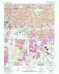
1965 Map of Southeast Memphis
USGS Topo · Published 1984About this map
The expanding urban footprint of Memphis dominates this mid-1960s survey, updated in the early 1980s to show the rapid sprawl of residential and industrial developments. Major infrastructure hubs like the Memphis International Airport and the sprawling Tennessee Yards rail facility anchor the southern half of the sheet, while the Mid-South Fairgrounds and Memphis State University define the established northern neighborhoods. The map captures a transitional era as smaller outlying settlements like Oakville and Capleville were being absorbed into the metropolitan reach.
Find a feature on this map
67 named features on this map. Tap any name to fly to it.
Don’t see what you’re looking for? This feature index may not catch every label — zoom into the map to look around manually.
Map Details
Editions of this 1965 Southeast Memphis Map
4 editions found
Other maps of this area

1916 · Memphis
USGS Topo · 1:62,500

1925 · Memphis
USGS Topo · 1:48,000

1927 · Memphis
USGS Topo · 1:62,500

1932 · Horn Lake
USGS Topo · 1:48,000

1935 · Horn Lake
USGS Topo · 1:62,500

1939 · Memphis
USGS Topo · 1:62,500

1944 · Hernando
USGS Topo · 1:62,500

1948 · Helena
USGS Topo · 1:250,000

1950 · Helena
USGS Topo · 1:250,000

1953 · Memphis
USGS Topo · 1:250,000