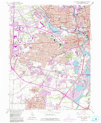
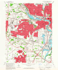
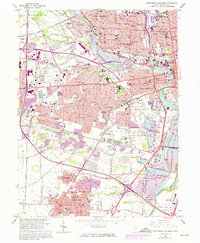
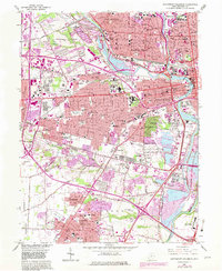
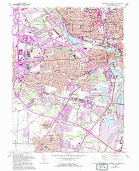
1965 Map of Southwest Columbus
USGS Topo · Published 1991About this map
Columbus and its southwestern suburbs undergo significant expansion in the mid-1960s, a transformation tracked by later purple revisions that show the outward push of the Columbus Corp Bdy. The industrial and residential landscape is heavily defined by the convergence of major rail lines, including Conrail, the Baltimore and Ohio, and the Chesapeake and Ohio, which serve as the skeleton for the growth of communities like Urbancrest and Grove City.
Find a feature on this map
59 named features on this map. Tap any name to fly to it.
Don’t see what you’re looking for? This feature index may not catch every label — zoom into the map to look around manually.
Map Details
Editions of this 1965 Southwest Columbus Map
5 editions found
Other maps of this area

1901 · Dublin
USGS Topo · 1:62,500

1902 · Westerville
USGS Topo · 1:62,500

1903 · Dublin
USGS Topo · 1:62,500

1904 · Westerville
USGS Topo · 1:62,500

1923 · West Columbus
USGS Topo · 1:62,500
1925 · East Columbus
USGS Topo · 1:62,500

1925 · West Columbus
USGS Topo · 1:62,500

1943 · East Columbus
USGS Topo · 1:62,500

1947 · Columbus
USGS Topo · 1:250,000

1950 · Marion
USGS Topo · 1:250,000
Featured Places
- Columbus, OH
- Upper Arlington, OH
- Grove City, Jackson Township
- Grandview Heights, OH
- Urbancrest, Jackson Township