
1947 Map of Speed
USGS Topo · Published 1947About this map
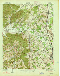
Clark State Forest occupies the northwestern corner of this territory, where the prominent Knobs topography transitions into the drainage of the Muddy Fork. The 1940s landscape is defined by its transit networks, notably the Indiana Electric line and the Pennsylvania railroad, which parallel Silver Creek through the eastern settlements. The town of Sellersburg and the industrial node at Speed serve as centers of activity near the confluence of Silver Creek and Narrow Gage Run. Genealogists will find a wealth of specific landmarks, from rural schoolhouses like Warmans Sch and Pleasant Valley Sch to numerous family-named burial grounds including Hickory Grove Cem and Hendrick Cem. The southern edge captures the boundary between Clark Co and Floyd Co, marked by smaller communities like St Joseph and churches such as Atkins Chapel.
Find a feature on this map
41 named features on this map. Tap any name to fly to it.
Don’t see what you’re looking for? This feature index may not catch every label — zoom into the map to look around manually.
Map Details
Editions of this 1947 Speed Map
2 editions found
Other maps of this area

1905 · Prospect
USGS Topo · 1:62,500

1912 · Prospect
USGS Topo · 1:62,500

1937 · Jeffersonville
USGS Topo · 1:24,000

1937 · Charlestown
USGS Topo · 1:24,000

1938 · Speed
USGS Topo · 1:24,000

1939 · New Albany
USGS Topo · 1:24,000

1939 · Georgetown
USGS Topo · 1:24,000

1941 · Borden
USGS Topo · 1:24,000

1946 · Jeffersonville
USGS Topo · 1:24,000

1946 · New Albany
USGS Topo · 1:24,000