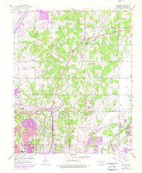
1956 Map of Spencer
USGS Topo · Published 1976About this map
Oklahoma City expands northeastward in this mid-century survey, revealing a landscape transitioning from rural oil and gas production to suburban density. The map captures the convergence of major infrastructure, including the Turner Turnpike (Toll Road) and multiple rail lines like the St Louis San Francisco and Atchison Topeka and Santa Fe. Cultural landmarks define the western edge, from the Cowboy Hall of Fame and Zoo near Northeast Lake to the campus of Oklahoma Christian College. Extensive petroleum development is evident through clusters of Oil Wells and Gas Wells that pepper the terrain between the North Canadian River and the rural community of Witcher. Large commemorative sites like Memorial Park Cemetery and Arlington Memorial Park Cemetery mark the edges of the growing urban core.
Find a feature on this map
76 named features on this map. Tap any name to fly to it.
Don’t see what you’re looking for? This feature index may not catch every label — zoom into the map to look around manually.
Map Details
Editions of this 1956 Spencer Map
3 editions found
Other maps of this area

1892 · Moore
USGS Topo · 1:62,500

1892 · Edmond
USGS Topo · 1:62,500

1892 · Kingfisher
USGS Topo · 1:125,000

1893 · Oklahoma City
USGS Topo · 1:62,500

1895 · Kingfisher
USGS Topo · 1:125,000

1898 · Purcell
USGS Topo · 1:125,000

1904 · Chickasha
USGS Topo · 1:125,000

1934 · Crutcho Creek
USGS Topo · 1:24,000

1934 · Moore
USGS Topo · 1:62,500

1935 · Spencer
USGS Topo · 1:24,000