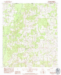
1983 Map of Spring Creek
USGS Topo · Published 1984About this map
The Tangipahoa River carves through the borderlands of Louisiana and Mississippi, anchoring a landscape defined by small timber-and-creek settlements in the early 1980s. This survey focuses on the communities of Spring Creek, Lewiston, and Irving, where local life is organized around numerous family cemeteries and country churches. The density of sites like the McDaniel Cem, Cutrer Cem, and Pierce Cem suggests deep-rooted genealogical history across the Pike County and Tangipahoa Parish line. Transport and commerce are evidenced by the Illinois Central Gulf railroad cutting through the northwest corner near Greenlaw, while the dense network of waterways, including Little Silver Creek and Chubby Creek, illustrates the drainage patterns vital to the area's rural character. Education and community landmarks such as Hagen Sch and Midway Ch provide specific points of interest for local historians studying the social fabric of this interstate boundary region.
Find a feature on this map
37 named features on this map. Tap any name to fly to it.
Don’t see what you’re looking for? This feature index may not catch every label — zoom into the map to look around manually.
Map Details
Editions of this 1983 Spring Creek Map
This is the sole edition of this map. No revisions or reprints were ever made.
Other maps of this area

1939 · Sunny Hill
USGS Topo · 1:31,680

1940 · Spring Creek
USGS Topo · 1:31,680

1940 · Roseland
USGS Topo · 1:31,680

1942 · Roseland
USGS Topo · 1:31,680

1942 · Wilmer
USGS Topo · 1:31,680

1949 · Bolivar
USGS Topo · 1:31,680

1950 · Kentwood
USGS Topo · 1:31,680

1953 · Natchez
USGS Topo · 1:250,000

1954 · Baton Rouge
USGS Topo · 1:250,000

1956 · Natchez
USGS Topo · 1:250,000