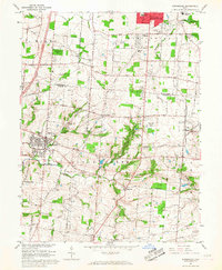
1965 Map of Springboro
USGS Topo · Published 1967About this map
Centerville and Springboro anchor this mid-1960s topographic survey at the intersection of Montgomery and Warren counties. The landscape transition is evident as the suburban growth of Centerville in Washington Township meets the agricultural reaches of Clear Creek. The area is bisected by extensive pipelines and the Pennsylvania railroad corridor, which skirts the eastern edge near Lytle. Local genealogy and land use are well-documented through numerous burial grounds like Rehoboth Cem, Salem Cem, and the Miami Valley Memorial Garden. Cultural and educational landmarks of the era include St Leonards College and the Montgomery County Airport, while smaller crossroads like Five Points and Ridgeville maintain their rural character along the Clear Creek drainage.
Find a feature on this map
59 named features on this map. Tap any name to fly to it.
Don’t see what you’re looking for? This feature index may not catch every label — zoom into the map to look around manually.
Map Details
Editions of this 1965 Springboro Map
4 editions found
Other maps of this area

1904 · Mason
USGS Topo · 1:62,500

1906 · Mason
USGS Topo · 1:62,500

1908 · Miamisburg
USGS Topo · 1:62,500

1913 · Waynesville
USGS Topo · 1:62,500

1914 · Morrow
USGS Topo · 1:62,500

1915 · Waynesville
USGS Topo · 1:62,500

1916 · Morrow
USGS Topo · 1:62,500

1951 · Franklin
USGS Topo · 1:24,000

1953 · Cincinnati
USGS Topo · 1:250,000

1955 · Monroe
USGS Topo · 1:24,000