
1929 Map of Springdale
USGS Topo · Published 1929About this map
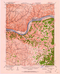
The Ohio River shoreline and the steep, dissected uplands of Mason and Lewis Counties define this 1929 landscape during the peak of the Chesapeake and Ohio railroad era. The river serves as a bustling corridor of transit and infrastructure, marked by Dam 33 and the sprawling riverfront of Maysville. Inland, the map reveals a dense network of upland rural life, where community identity was centered around family-named schools and small churches such as Oak Hill Sch, Ebenezer Ch, and Richland Sch.
Find a feature on this map
68 named features on this map. Tap any name to fly to it.
Don’t see what you’re looking for? This feature index may not catch every label — zoom into the map to look around manually.
Map Details
Editions of this 1929 Springdale Map
2 editions found
Other maps of this area

1915 · Maysville
USGS Topo · 1:62,500

1916 · Peebles
USGS Topo · 1:62,500

1918 · Peebles
USGS Topo · 1:62,500

1918 · Seaman
USGS Topo · 1:62,500

1919 · Maysville
USGS Topo · 1:62,500

1919 · Vanceburg
USGS Topo · 1:62,500

1928 · Higginsport
USGS Topo · 1:48,000

1931 · Higginsport
USGS Topo · 1:62,500

1935 · Springdale
USGS Topo · 1:62,500

1949 · Vanceburg
USGS Topo · 1:62,500