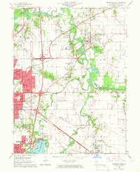
1965 Map of Springfield East
USGS Topo · Published 1966About this map
Springfield and its eastern suburbs are shown here in the mid-1960s, a period of transition where traditional river-and-rail infrastructure met the expanding highway system. The Sangamon River and its South Fork anchor the landscape, which is marked by several significant burial grounds including the historic Camp Butler Cem and Roselawn Memorial Cemetery. Industrial activity is evident in the numerous Claypits and the presence of the Norfolk and Western and Illinois Terminal railroads. This survey provides a look at the area before later suburban development, preserving the locations of smaller communities like Bissell, Riverton, and Rochester. To the south, the recently established Lake Springfield and its Spaulding Dam have reshaped the local hydrology, while local landmarks like the St Johns Sanitarium and the Drive-in Theater reflect the social fabric of Sangamon County at the time.
Find a feature on this map
86 named features on this map. Tap any name to fly to it.
Don’t see what you’re looking for? This feature index may not catch every label — zoom into the map to look around manually.
Map Details
Editions of this 1965 Springfield East Map
4 editions found
Other maps of this area

1907 · Springfield
USGS Topo · 1:62,500

1922 · Divernon
USGS Topo · 1:62,500

1923 · Taylorville
USGS Topo · 1:62,500

1924 · Divernon
USGS Topo · 1:62,500

1925 · Taylorville
USGS Topo · 1:62,500

1930 · Springfield
USGS Topo · 1:62,500

1940 · Springfield
USGS Topo · 1:62,500

1950 · Springfield West
USGS Topo · 1:24,000

1950 · Springfield East
USGS Topo · 1:24,000

1954 · Mechanicsburg
USGS Topo · 1:62,500