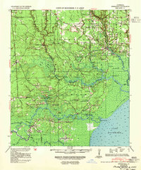
1939 Map of Springfield
USGS Topo · Published 1954About this map
Livingston Parish is defined by its intricate network of river-based commerce and small rural centers during the 1930s. The Tickfaw River and Amite River serve as primary arteries, lined with numerous landings such as Warsaw Ldg, Tucker Ldg, and Gunboat Ldg, indicating the area's historical reliance on water transport before the full modernization of the road network. These rivers empty into the northern reaches of Lake Maurepas, a landscape of islands and bayous including Bear Island and Chenal Blanc Bayou.
Find a feature on this map
82 named features on this map. Tap any name to fly to it.
Don’t see what you’re looking for? This feature index may not catch every label — zoom into the map to look around manually.
Map Details
Editions of this 1939 Springfield Map
2 editions found
Other maps of this area

1892 · Mount Airy
USGS Topo · 1:62,500

1892 · Bonnet Carre
USGS Topo · 1:62,500

1892 · Donaldsonville
USGS Topo · 1:62,500

1934 · Denham Springs
USGS Topo · 1:62,500

1934 · Springfield
USGS Topo · 1:62,500

1935 · Ponchatoula
USGS Topo · 1:62,500

1936 · Ruddock
USGS Topo · 1:31,680

1936 · Bonnet Carre
USGS Topo · 1:62,500

1939 · Ponchatoula
USGS Topo · 1:62,500

1939 · Springfield
USGS Topo · 1:62,500