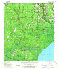
1963 Map of Springfield
USGS Topo · Published 1967About this map
Livingston Parish and Tangipahoa Parish meet amidst a dense network of waterways leading to the northern shores of Lake Maurepas. This landscape is defined by the convergence of the Amite River, Tickfaw River, and the Tangipahoa River, each winding through complex swamp environments like Gum Swamp and Big Branch. The settlement pattern follows the high ground and riverbanks, with numerous historical landings such as Tiger Bluff Landing and Neal Landing marking the transition from water-based transport to the inland roads.
Find a feature on this map
109 named features on this map. Tap any name to fly to it.
Don’t see what you’re looking for? This feature index may not catch every label — zoom into the map to look around manually.
Map Details
Editions of this 1963 Springfield Map
2 editions found
Other maps of this area

1892 · Mount Airy
USGS Topo · 1:62,500

1892 · Bonnet Carre
USGS Topo · 1:62,500

1892 · Donaldsonville
USGS Topo · 1:62,500

1934 · Denham Springs
USGS Topo · 1:62,500

1934 · Springfield
USGS Topo · 1:62,500

1935 · Ponchatoula
USGS Topo · 1:62,500

1936 · Ruddock
USGS Topo · 1:31,680

1936 · Bonnet Carre
USGS Topo · 1:62,500

1939 · Ponchatoula
USGS Topo · 1:62,500

1939 · Springfield
USGS Topo · 1:62,500