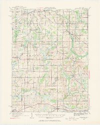
1919 Map of Springport
USGS Topo · Published 1968About this map
Springport and Eaton Rapids anchor this rural landscape as it appeared just after the First World War. The area is defined by a dense network of one-room schoolhouses such as Boody School, Knight School, and Sherd School, reflecting the decentralized community structure of the early 20th century. The Michigan Central Railroad cuts across the terrain, serving small agricultural junctions like Charlesworth and Devereaux. The geography is characterized by glacial features, including the Spicerville Hills and numerous small water bodies like Lanes Lake and Boody Lake. Historical transportation routes are prominent, including the Old Plank Road and the Detroit and Chicago Road, which follow older established paths through the countryside. Near the southern edge, the settlement of Parma sits along the rail line, while the eastern section is marked by the winding path of the Grand River and the rural center at Onondaga.
Find a feature on this map
96 named features on this map. Tap any name to fly to it.
Don’t see what you’re looking for? This feature index may not catch every label — zoom into the map to look around manually.
Map Details
Editions of this 1919 Springport Map
3 editions found
Other maps of this area

1909 · Mason
USGS Topo · 1:62,500

1910 · Lansing
USGS Topo · 1:62,500

1911 · Mason
USGS Topo · 1:62,500

1912 · Lansing
USGS Topo · 1:62,500

1919 · Springport
USGS Topo · 1:62,500

1919 · Rives Junction
USGS Topo · 1:62,500

1921 · Rives Junction
USGS Topo · 1:62,500

1921 · Springport
USGS Topo · 1:62,500

1921 · Marshall
USGS Topo · 1:62,500

1923 · Marshall
USGS Topo · 1:62,500