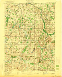
1921 Map of Springport
USGS Topo · Published 1921About this map
Eaton Rapids and the upper reaches of the Grand River anchor this early twentieth-century survey of south-central Michigan. The landscape is defined by a dense grid of rural education, featuring dozens of local landmarks like the Quaker School, Landon School, and Favorite School which served the farming communities of Hamlin and Springport townships. The transportation network is dominated by the Michigan Central Railroad, which connects the villages of Parma and Devereaux in the south, while the Detroit Electric line runs through the southwest corner near Albion. Notable industrial and social landmarks include the Smithville Dam on the river and the Campground near the northern border, reflecting the area's mixed utility as both a productive agricultural zone and a gathering place. Waterways such as Willow Creek and Sandstone Creek meander through the glacial terrain, passing small settlements like Kinneville and Tompkins Center.
Find a feature on this map
95 named features on this map. Tap any name to fly to it.
Don’t see what you’re looking for? This feature index may not catch every label — zoom into the map to look around manually.
Map Details
Editions of this 1921 Springport Map
2 editions found
Other maps of this area

1909 · Mason
USGS Topo · 1:62,500

1910 · Lansing
USGS Topo · 1:62,500

1911 · Mason
USGS Topo · 1:62,500

1912 · Lansing
USGS Topo · 1:62,500

1919 · Springport
USGS Topo · 1:62,500

1919 · Rives Junction
USGS Topo · 1:62,500

1921 · Rives Junction
USGS Topo · 1:62,500

1921 · Springport
USGS Topo · 1:62,500

1921 · Marshall
USGS Topo · 1:62,500

1923 · Marshall
USGS Topo · 1:62,500