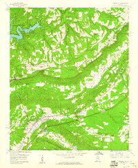
1958 Map of Springville
USGS Topo · Published 1960About this map
Blount Mountain and Jones Mountain define this Alabama landscape in the late 1950s, creating a corridor of valleys where the Southern railroad and Big Canoe Creek dominate the local geography. The settlement of Springville serves as a hub near the southwestern edge of the sheet, while Saint Clair Springs marks a historic locale to the east. This era of transformation is captured in the infrastructure, specifically the major roadway marked as Under Construction paralleling the existing rail lines.
Find a feature on this map
38 named features on this map. Tap any name to fly to it.
Don’t see what you’re looking for? This feature index may not catch every label — zoom into the map to look around manually.
Map Details
Editions of this 1958 Springville Map
4 editions found
Other maps of this area

1889 · Springville
USGS Topo · 1:125,000

1889 · Birmingham
USGS Topo · 1:125,000

1892 · Birmingham
USGS Topo · 1:125,000

1892 · Springville
USGS Topo · 1:125,000

1895 · Birmingham
USGS Topo · 1:125,000

1905 · Leeds
USGS Topo · 1:62,500

1907 · Birmingham
USGS Topo · 1:125,000

1907 · Leeds
USGS Topo · 1:62,500

1953 · Birmingham
USGS Topo · 1:250,000

1956 · Birmingham
USGS Topo · 1:250,000