
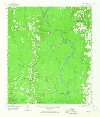
1958 Map of Spurger
USGS Topo · Published 1960About this map
The Neches River carves a winding path through this corner of the Big Thicket, defining the boundary between Tyler and Jasper counties. In the late 1950s, the landscape was a mix of conservation, industry, and small rural communities. The Magnolia Springs State Nursery stands in the northeast near Magnolia Springs, while the western hills are dotted with scattered oil and gas developments, including the Joes Lake Oil Field. Small rural centers such as Spurger and Fred are connected by narrow roads and an Old Railroad Grade that speaks to the region's timber history. Numerous family-named landmarks and country churches, such as Spring Hill Ch and Lilly-of-the-Valley Ch, are interspersed among the oxbow lakes like Horseshoe Lake and Sally Withers Lake, providing a detailed look at the era's local settlement patterns.
Find a feature on this map
53 named features on this map. Tap any name to fly to it.
Don’t see what you’re looking for? This feature index may not catch every label — zoom into the map to look around manually.
Map Details
Editions of this 1958 Spurger Map
2 editions found
Other maps of this area

1952 · Lake Charles
USGS Topo · 1:250,000

1954 · Lake Charles
USGS Topo · 1:250,000

1954 · Beaumont
USGS Topo · 1:250,000

1955 · Roganville
USGS Topo · 1:62,500

1955 · Silsbee
USGS Topo · 1:62,500

1955 · Kountze
USGS Topo · 1:62,500

1955 · Woodville
USGS Topo · 1:62,500

1955 · Bessmay
USGS Topo · 1:62,500

1955 · Curtis
USGS Topo · 1:62,500

1957 · Beaumont
USGS Topo · 1:250,000