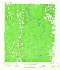
1958 Map of Spurger
USGS Topo · Published 1967About this map
The Neches River winds through this East Texas landscape, marking the boundary between Tyler, Jasper, and Hardin counties during the late 1950s. The region is defined by a sparse settlement pattern centered around small communities like Spurger and Fred, where life was anchored by local institutions such as the High Sch and Beech Creek Ch. The geography reveals a heavy reliance on the land's resources, with several oil developments including the Joes Lake Oil Field and Jackson-Doty Oil Field dotting the terrain. Natural features like Maple Slough and Sally Withers Lake emphasize the river's influence on the low-lying basin. Notable for local history, the map preserves the locations of family-associated sites and rural landmarks like the Withers Cem and Cunningham Chapel, alongside vestiges of former timber operations indicated by the Old Railroad Grade.
Find a feature on this map
54 named features on this map. Tap any name to fly to it.
Don’t see what you’re looking for? This feature index may not catch every label — zoom into the map to look around manually.
Map Details
Editions of this 1958 Spurger Map
2 editions found

Other maps of this area

1952 · Lake Charles
USGS Topo · 1:250,000

1954 · Lake Charles
USGS Topo · 1:250,000

1954 · Beaumont
USGS Topo · 1:250,000

1955 · Roganville
USGS Topo · 1:62,500

1955 · Silsbee
USGS Topo · 1:62,500

1955 · Kountze
USGS Topo · 1:62,500

1955 · Woodville
USGS Topo · 1:62,500

1955 · Bessmay
USGS Topo · 1:62,500

1955 · Curtis
USGS Topo · 1:62,500

1957 · Beaumont
USGS Topo · 1:250,000