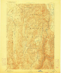
1894 Map of Squaw Creek
USGS Topo · Published 1917About this map
Walker Mill and the early river crossing at Smith Ferry anchor this reconnaissance of central Idaho, reflecting the area's late nineteenth-century reliance on timber and water-borne transit. Surveyed in the 1890s, the landscape is defined by the heavy timber of the Payette National Forest and the Weiser Nat Forest, intersected by the winding corridor of the North Fork Payette River. Small settlements like Alpha and Ola appear as isolated outposts amidst a terrain of broad topographic features, including Lava Flat and Big Flat. The transition from the North Fork Range into fertile basins like High Valley and Sage Hen Valley illustrates the region's suitability for seasonal grazing and early homesteading before the expansion of more permanent infrastructure.
Find a feature on this map
37 named features on this map. Tap any name to fly to it.
Don’t see what you’re looking for? This feature index may not catch every label — zoom into the map to look around manually.
Map Details
Editions of this 1894 Squaw Creek Map
5 editions found
Other maps of this area

1892 · Boise
USGS Topo · 1:125,000

1894 · Squaw Creek
USGS Topo · 1:125,000

1894 · Idaho Basin
USGS Topo · 1:125,000

1897 · Boise
USGS Topo · 1:125,000

1897 · Weiser
USGS Topo · 1:125,000

1898 · Nampa
USGS Topo · 1:125,000

1909 · Garden Valley
USGS Topo · 1:125,000

1911 · Meadows
USGS Topo · 1:125,000

1953 · Smiths Ferry
USGS Topo · 1:62,500

1953 · Boiling Springs
USGS Topo · 1:62,500