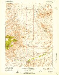
1953 Map of Squaw Rock
USGS Topo · Published 1954About this map
Squaw Mountain and the Cooney Hills dominate this mid-century landscape in Platte and Albany Counties, where the high plains meet rugged peaks. The 1953 field check documents a territory defined by industrial extraction and complex water management for the Missouri River Basin development. Prospectors and mining historians will find specific interest in the mining operations concentrated in the eastern hills, including the Precious Honor Mine No 1, Precious Honor Mine No 2, and other sites noted as Mine (Inactive) or Mine (Abandoned).
Find a feature on this map
17 named features on this map. Tap any name to fly to it.
Don’t see what you’re looking for? This feature index may not catch every label — zoom into the map to look around manually.
Map Details
Editions of this 1953 Squaw Rock Map
3 editions found
Other maps of this area

1953 · Natwick SW
USGS Topo · 1:24,000

1953 · Hightower
USGS Topo · 1:24,000

1953 · Natwick
USGS Topo · 1:24,000

1953 · Squaw Rock
USGS Topo · 1:24,000

1953 · Hightower SW
USGS Topo · 1:24,000

1953 · Richeau Hills
USGS Topo · 1:24,000

1954 · Torrington
USGS Topo · 1:250,000

1954 · Cheyenne
USGS Topo · 1:250,000

1955 · Poe Mountain
USGS Topo · 1:24,000

1955 · Moonshine Peak
USGS Topo · 1:24,000