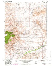
1953 Map of Squaw Rock
USGS Topo · Published 1982About this map
Mining activity and irrigation engineering dominate this corner of Platte County, where the Cooney Hills rise above the drainage of the Laramie River. Prospectors once sought fortune at the Precious Honor Mine No 1 and Precious Honor Mine No 2, while other sites are marked simply as Mine (Inactive). The landscape reflects the importance of water management in this arid region, most notably seen in the path of the Wyoming Development Company Canal (Aban'd) and a Gaging Sta along Sybille Creek.
Find a feature on this map
22 named features on this map. Tap any name to fly to it.
Don’t see what you’re looking for? This feature index may not catch every label — zoom into the map to look around manually.
Map Details
Editions of this 1953 Squaw Rock Map
3 editions found
Other maps of this area

1953 · Natwick SW
USGS Topo · 1:24,000

1953 · Hightower
USGS Topo · 1:24,000

1953 · Natwick
USGS Topo · 1:24,000

1953 · Squaw Rock
USGS Topo · 1:24,000

1953 · Hightower SW
USGS Topo · 1:24,000

1953 · Richeau Hills
USGS Topo · 1:24,000

1954 · Torrington
USGS Topo · 1:250,000

1954 · Cheyenne
USGS Topo · 1:250,000

1955 · Poe Mountain
USGS Topo · 1:24,000

1955 · Moonshine Peak
USGS Topo · 1:24,000