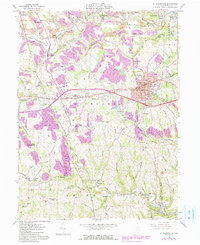
1905 Map of St. Clairsville
USGS Topo · Published 1948About this map
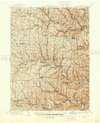
St. Clairsville and the surrounding Belmont County hill country are depicted here in the early twentieth century, showing a landscape defined by an intricate network of narrow ridges and deeply incised stream valleys. The town of St. Clairsville sits along the historic National Road, which bisects the southern half of the quadrangle. This era was one of intense industrial and transit development, as seen in the dense cluster of railroads like the Wheeling and Lake Erie R.R. and the Baltimore and Ohio R.R. following the winding paths of Short Creek and Wheeling Creek. Smaller hamlets and post offices such as Georgetown Short Cr. P.O. and Pasco Blaine P.O. dot the map, marking the importance of mail stops for these rural communities before rural electrification and modern highways reshaped the region. Coal-related names like Coal Run and Coaly Hollow hint at the burgeoning mining economy that fueled the local rail lines.
Find a feature on this map
111 named features on this map. Tap any name to fly to it.
Don’t see what you’re looking for? This feature index may not catch every label — zoom into the map to look around manually.
Map Details
Editions of this 1905 St. Clairsville Map
2 editions found