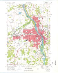
1974 Map of St. Cloud
USGS Topo · Published 1976About this map
The Mississippi River serves as the central artery for this mid-1970s look at Stearns, Benton, and Sherburne counties. The urban core of St Cloud is extensively detailed, showing the expansion of St Cloud State College and the clustering of several major parochial institutions like St Marys Sch and Holy Spirit Sch. The industrial and transport character of the era is evident in the Burlington Northern rail lines and the numerous quarries and gravel pits that dot the landscape, particularly west of the city near Waite Park. To the south, the river's character changes as it flows past the Beaver Islands, while the eastern bank is home to the refined landscape of Munsinger Gardens. Extensive cemetery records are preserved here, including Sacred Heart Cem and Assumption Cem, providing valuable location data for genealogical research.
Find a feature on this map
80 named features on this map. Tap any name to fly to it.
Don’t see what you’re looking for? This feature index may not catch every label — zoom into the map to look around manually.
Map Details
Editions of this 1974 St. Cloud Map
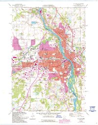
2 editions found
Other maps of this area

1950 · St. Cloud
USGS Topo · 1:62,500

1951 · Annandale
USGS Topo · 1:62,500

1953 · Saint Cloud
USGS Topo · 1:250,000

1957 · Saint Cloud
USGS Topo · 1:250,000

1958 · Saint Cloud
USGS Topo · 1:250,000

1965 · St Stephen
USGS Topo · 1:24,000

1965 · St Joseph
USGS Topo · 1:24,000

1967 · Rockville
USGS Topo · 1:24,000
1974 · Cable
USGS Topo · 1:24,000
1974 · St Augusta
USGS Topo · 1:24,000