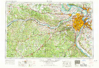
1963 Map of St. Louis
USGS Topo · Published 1970About this map
The Missouri River and Mississippi River converge at the heart of this regional survey, defining the industrial and transportation geography of the gateway to the West. In the early 1960s, the urban expansion of St Louis is evident through the dense networks of Interstate 70 and US Highway 66, connecting established suburbs like Webster Groves, Kirkwood, and Florissant. The map captures the city's civic identity at the Jefferson National Expansion Memorial and St Louis University, while the riverfronts are marked by the St Louis Ordnance Plant and extensive rail lines including the Missouri Pacific RR.
Find a feature on this map
55 named features on this map. Tap any name to fly to it.
Don’t see what you’re looking for? This feature index may not catch every label — zoom into the map to look around manually.
Map Details
Editions of this 1963 St. Louis Map
4 editions found
Other maps of this area

1886 · Jefferson City
USGS Topo · 1:125,000

1888 · Tuscumbia
USGS Topo · 1:125,000

1888 · St. Louis
USGS Topo · 1:62,500

1890 · Louisiana
USGS Topo · 1:125,000
1890 · Mexico
USGS Topo · 1:125,000

1890 · Moberly
USGS Topo · 1:125,000

1890 · Hermann
USGS Topo · 1:125,000

1890 · Fulton
USGS Topo · 1:125,000

1894 · Tuscumbia
USGS Topo · 1:125,000
1894 · Jefferson City
USGS Topo · 1:125,000