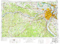
1963 Map of St. Louis
USGS Topo · Published 1974About this map
The Missouri River and Mississippi River converge at the heart of this mid-century landscape, anchoring a massive metropolitan corridor that stretches from St. Louis and Belleville in the east to Fulton in the west. This era of urban expansion is marked by the nascent Jefferson National Expansion Memorial and the busy operations at Lambert-St. Louis International Airport. To the southwest, the industrial footprint of the Ozark Plateau comes into focus, where the Viburnum Mines and Pea Ridge Mine indicate the region's deep-rooted mining economy.
Find a feature on this map
288 named features on this map. Tap any name to fly to it.
Don’t see what you’re looking for? This feature index may not catch every label — zoom into the map to look around manually.
Map Details
Editions of this 1963 St. Louis Map
4 editions found

Other maps of this area

1886 · Jefferson City
USGS Topo · 1:125,000

1888 · Tuscumbia
USGS Topo · 1:125,000

1888 · St. Louis
USGS Topo · 1:62,500

1890 · Louisiana
USGS Topo · 1:125,000

1890 · Mexico
USGS Topo · 1:125,000

1890 · Moberly
USGS Topo · 1:125,000

1890 · Hermann
USGS Topo · 1:125,000

1890 · Fulton
USGS Topo · 1:125,000

1894 · Tuscumbia
USGS Topo · 1:125,000

1894 · Jefferson City
USGS Topo · 1:125,000