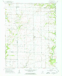
1962 Map of St. Rose
USGS Topo · Published 1963About this map
St Rose serves as a central hub in this early 1960s topographic survey of the Illinois prairie, where the boundaries of Madison, Bond, and Clinton counties intersect. The landscape is defined by its drainage patterns, with Shoal Creek winding along the eastern edge and the Lake Branch carving through the center. Small rural clusters like Jamestown and Sebastopol are connected by a grid of section-line roads, illustrating the organized agricultural development of the era. Genealogists will find particular value in the documentation of the Lake Branch Cemetery and Bethany Church, which served the outlying farmstead communities. The map captures the region's transition from purely rural townships like Helvetia and Burgess into a more modernized post-war rural landscape, just as photogrammetric methods were refining local cartography.
Find a feature on this map
18 named features on this map. Tap any name to fly to it.
Don’t see what you’re looking for? This feature index may not catch every label — zoom into the map to look around manually.
Map Details
Editions of this 1962 St. Rose Map
2 editions found
Other maps of this area

1906 · Breese
USGS Topo · 1:62,500

1907 · Breese
USGS Topo · 1:62,500

1910 · Carlyle
USGS Topo · 1:62,500

1932 · Greenville
USGS Topo · 1:62,500

1937 · New Douglas
USGS Topo · 1:48,000

1939 · Greenville
USGS Topo · 1:62,500

1943 · Greenville
USGS Topo · 1:62,500

1944 · New Douglas
USGS Topo · 1:62,500

1948 · Carlyle
USGS Topo · 1:62,500
1957 · Highland
USGS Topo · 1:24,000