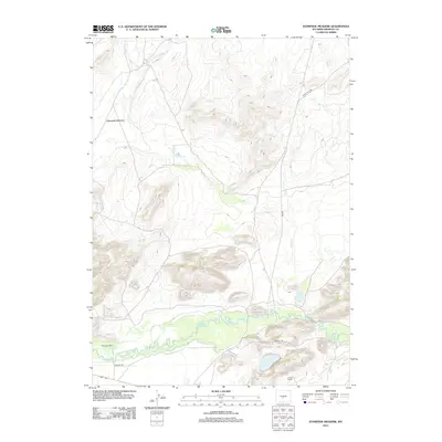
2012 Map of Stampede Meadow
USGS Topo · Published 2012About this map
The Oregon Trl cuts across the southern portion of this landscape, a corridor of movement that parallels the winding Sweetwater River. This arid stretch of Fremont County is defined by its water management and sparse ranching outposts, where the Emigrant Ditch diverts water to support localized agriculture and livestock. Settlement is anchored by the McIntosh Ranch in the west and Claytor Ranch in the southeast, representing the enduring pastoral footprint in the high desert. To the north, the terrain rises toward Stampede Meadow, drained by a network of seasonal watercourses including Buffalo Cr and Tin Cup Cr. Primitive routes like Ore Rd and Black Rock Rd provide the only land access through this open country, illustrating the remoteness of the region even in the early twenty-first century.
Find a feature on this map
10 named features on this map. Tap any name to fly to it.
Don’t see what you’re looking for? This feature index may not catch every label — zoom into the map to look around manually.
Map Details
Editions of this 2012 Stampede Meadow Map
This is the sole edition of this map. No revisions or reprints were ever made.
Other maps of this area

1951 · Crooks Creek NE
USGS Topo · 1:24,000

1951 · Stampede Meadow
USGS Topo · 1:24,000

1951 · Black Rock Gap
USGS Topo · 1:24,000

1951 · Graham Ranch
USGS Topo · 1:24,000

1951 · Split Rock NW
USGS Topo · 1:24,000

1951 · Crooks Mountain
USGS Topo · 1:24,000

1952 · Tin Cup Mountain
USGS Topo · 1:24,000

1952 · Muskrat Basin
USGS Topo · 1:24,000

1952 · Coyote Springs
USGS Topo · 1:24,000

1955 · Casper
USGS Topo · 1:250,000