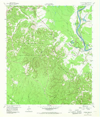
1960 Map of Stephen Creek
USGS Topo · Published 1969About this map
The Trinity River forms a dominant natural boundary along the northeastern edge of this East Texas terrain, dividing San Jacinto and Polk counties. In 1960, the landscape was defined by the dense timber of the Sam Houston National Forest, where a network of seasonal drainages like Caney Creek and McCombs Creek carved through the upland ridges. Local life was anchored by small settlements such as Pointblank and Stephen Creek, with rural congregation points like Snow Hill Ch and Paul Harbor Memorial Ch serving the outlying communities.
Find a feature on this map
54 named features on this map. Tap any name to fly to it.
Don’t see what you’re looking for? This feature index may not catch every label — zoom into the map to look around manually.
Map Details
Editions of this 1960 Stephen Creek Map
Other maps of this area

1954 · Beaumont
USGS Topo · 1:250,000

1957 · Beaumont
USGS Topo · 1:250,000

1960 · Blanchard
USGS Topo · 1:24,000

1960 · Maynard
USGS Topo · 1:24,000

1960 · Carlisle
USGS Topo · 1:24,000

1960 · Stephen Creek
USGS Topo · 1:24,000

1960 · Camilla
USGS Topo · 1:24,000

1960 · Coldspring
USGS Topo · 1:24,000

1961 · Staley
USGS Topo · 1:24,000

1961 · Onalaska
USGS Topo · 1:24,000