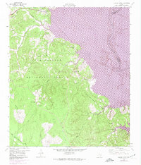
1960 Map of Stephen Creek
USGS Topo · Published 1974About this map
The Sam Houston National Forest dominates this landscape, where the dense timber of East Texas meets the rising waters of the Trinity River basin. In the early 1970s, the creation of Lake Livingston fundamentally altered the local topography, with large swaths of the Trinity River valley marked for controlled inundation. This transition from river bottomland to reservoir shoreline is captured alongside established rural landmarks like the Willow Springs Lookout.
Find a feature on this map
27 named features on this map. Tap any name to fly to it.
Don’t see what you’re looking for? This feature index may not catch every label — zoom into the map to look around manually.
Map Details
Editions of this 1960 Stephen Creek Map
Other maps of this area

1954 · Beaumont
USGS Topo · 1:250,000

1957 · Beaumont
USGS Topo · 1:250,000

1960 · Blanchard
USGS Topo · 1:24,000

1960 · Maynard
USGS Topo · 1:24,000

1960 · Carlisle
USGS Topo · 1:24,000

1960 · Stephen Creek
USGS Topo · 1:24,000

1960 · Camilla
USGS Topo · 1:24,000

1960 · Coldspring
USGS Topo · 1:24,000

1961 · Staley
USGS Topo · 1:24,000

1961 · Onalaska
USGS Topo · 1:24,000