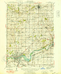
1948 Map of Sterling
USGS Topo · Published 1948About this map
The Rock River dominates this mid-century landscape, providing a geographical anchor for the twin industrial hubs of Sterling and Rock Falls. In the years following World War II, the area exhibits a dense network of rural infrastructure, with small crossroads such as Penrose and Prairieville serving the surrounding agricultural townships. The transportation framework is clearly defined by the Chicago and Northwestern and the Chicago Burlington and Quincy railroads, which facilitated the movement of goods through the Rock River Valley.
Find a feature on this map
85 named features on this map. Tap any name to fly to it.
Don’t see what you’re looking for? This feature index may not catch every label — zoom into the map to look around manually.
Map Details
Editions of this 1948 Sterling Map
2 editions found

Other maps of this area

1918 · Dixon
USGS Topo · 1:62,500

1922 · Oregon
USGS Topo · 1:62,500

1924 · Oregon
USGS Topo · 1:62,500

1930 · Woodsung
USGS Topo · 1:48,000

1932 · Prophetstown
USGS Topo · 1:48,000

1934 · Morrison
USGS Topo · 1:48,000

1936 · Prophetstown
USGS Topo · 1:62,500

1940 · Morrison
USGS Topo · 1:62,500

1942 · Mt Carroll
USGS Topo · 1:62,500

1942 · Forreston
USGS Topo · 1:62,500