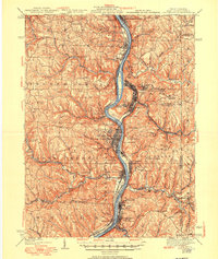
1942 Map of Steubenville
USGS Topo · Published 1950About this map
The Ohio River corridor serves as the industrial and transportation backbone of this region, where the steel-producing centers of Steubenville and Weirton face each other across the state line. During this era, the valley was densely networked with rail infrastructure, including the Pennsylvania RR, the Wheeling and Lake Erie Ry, and the Cleveland and Pittsburgh Div (P R R). The map reveals the expansion of residential districts into the surrounding hills, noted by neighborhoods like La Belle View, Marland Heights, and Vermont Terrace.
Find a feature on this map
102 named features on this map. Tap any name to fly to it.
Don’t see what you’re looking for? This feature index may not catch every label — zoom into the map to look around manually.
Map Details
Editions of this 1942 Steubenville Map
2 editions found

Other maps of this area

1901 · Cadiz
USGS Topo · 1:62,500

1901 · Beaver
USGS Topo · 1:62,500

1902 · Wheeling
USGS Topo · 1:62,500

1903 · Cadiz
USGS Topo · 1:62,500

1904 · Wellsville
USGS Topo · 1:62,500

1904 · Steubenville
USGS Topo · 1:62,500

1904 · Beaver
USGS Topo · 1:62,500

1904 · Burgettstown
USGS Topo · 1:62,500

1905 · St. Clairsville
USGS Topo · 1:62,500

1905 · Salineville
USGS Topo · 1:62,500