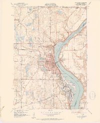
1951 Map of Stillwater
USGS Topo · Published 1952About this map
The St Croix River and St Croix Lake anchor this 1951 survey, capturing the industrial and institutional character of the borderlands between Minnesota and Wisconsin. The area is a dense hub of mid-century infrastructure, featuring the sprawling Minnesota State Prison at Bayport and the major rail lines of the Sault Ste Marie, Northern Pacific, and Chicago and North Western. This network of steel and water supported the regional economy of Stillwater, while the Interstate Bridge provided a vital link to Houlton and Hudson across the water.
Find a feature on this map
58 named features on this map. Tap any name to fly to it.
Don’t see what you’re looking for? This feature index may not catch every label — zoom into the map to look around manually.
Map Details
Editions of this 1951 Stillwater Map
4 editions found

Other maps of this area

1946 · Hudson
USGS Topo · 1:62,500

1946 · River Falls
USGS Topo · 1:62,500

1948 · New Richmond
USGS Topo · 1:62,500

1948 · Stillwater
USGS Topo · 1:62,500

1949 · New Richmond
USGS Topo · 1:62,500

1949 · River Falls
USGS Topo · 1:62,500

1949 · Hudson
USGS Topo · 1:62,500

1949 · Stillwater
USGS Topo · 1:62,500

1949 · Lake Elmo
USGS Topo · 1:24,000

1949 · Hudson
USGS Topo · 1:24,000