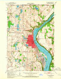
1951 Map of Stillwater
USGS Topo · Published 1966About this map
The St Croix River serves as the central artery for this mid-century look at the border between Minnesota and Wisconsin. The riverfront is dominated by the industrial and civic presence of Stillwater, which includes the Minnesota State Prison complex situated just north of Bayport. To the west, the landscape is peppered with smaller lakes like Silver Lake and Long Lake, while the eastern Wisconsin shore around Houlton remains largely rural. This era shows a community deeply integrated with its rail infrastructure, with lines like the Minneapolis St Paul and Sault Ste Marie and the Chicago and North Western threading through the river bluffs. Local institutions such as Lakeview Hospital and the Washington School mark the town's social center, while family histories are anchored at the Boutwell Cem and Rutherford Cem.
Find a feature on this map
58 named features on this map. Tap any name to fly to it.
Don’t see what you’re looking for? This feature index may not catch every label — zoom into the map to look around manually.
Map Details
Editions of this 1951 Stillwater Map
4 editions found

Other maps of this area

1946 · Hudson
USGS Topo · 1:62,500

1946 · River Falls
USGS Topo · 1:62,500

1948 · New Richmond
USGS Topo · 1:62,500

1948 · Stillwater
USGS Topo · 1:62,500

1949 · New Richmond
USGS Topo · 1:62,500

1949 · River Falls
USGS Topo · 1:62,500

1949 · Hudson
USGS Topo · 1:62,500

1949 · Stillwater
USGS Topo · 1:62,500

1949 · Lake Elmo
USGS Topo · 1:24,000

1949 · Hudson
USGS Topo · 1:24,000