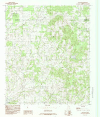
1984 Map of Stockard
USGS Topo · Published 1984About this map
Stockard and Pickens sit within a landscape defined by the drainage networks of the East Texas post oak belt during the mid-1980s. The northern reaches are anchored by Purtis Creek State Park, while the southwest corner reveals the expanding reach of the Cedar Creek Reservoir. The terrain is marked by distinct geological and topographical markers such as Big Rock and Melton Rock, providing a sense of the area's physical character before modern development intensified.
Find a feature on this map
21 named features on this map. Tap any name to fly to it.
Don’t see what you’re looking for? This feature index may not catch every label — zoom into the map to look around manually.
Map Details
Editions of this 1984 Stockard Map
This is the sole edition of this map. No revisions or reprints were ever made.
Other maps of this area

1920 · Kemp
USGS Topo · 1:62,500

1948 · Martins Mill
USGS Topo · 1:62,500

1949 · Martins Mill
USGS Topo · 1:62,500

1949 · Athens
USGS Topo · 1:62,500

1950 · Athens
USGS Topo · 1:62,500

1954 · Dallas
USGS Topo · 1:250,000

1956 · Tyler
USGS Topo · 1:250,000

1957 · Kemp
USGS Topo · 1:62,500

1958 · Dallas
USGS Topo · 1:250,000

1960 · Mabank
USGS Topo · 1:24,000