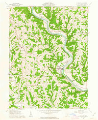
1961 Map of Stockport
USGS Topo · Published 1963About this map
The Muskingum River meanders through Morgan County, defining the local landscape and historic land divisions. This early 1960s survey documents the critical Congress Lands East of Ohio Company Purchase and Congress Lands North of Ohio Company Purchase boundaries. Along the river banks, the Baltimore and Ohio railroad tracks follow the water's path past Stockport, while the Big Bottom State Memorial Park marks a site of significant frontier history near Windsor.
Find a feature on this map
48 named features on this map. Tap any name to fly to it.
Don’t see what you’re looking for? This feature index may not catch every label — zoom into the map to look around manually.
Map Details
Editions of this 1961 Stockport Map
3 editions found
Other maps of this area

1902 · Parkersburg
USGS Topo · 1:62,500

1904 · Parkersburg
USGS Topo · 1:62,500

1904 · Chesterhill
USGS Topo · 1:62,500

1906 · Chesterhill
USGS Topo · 1:62,500

1909 · Caldwell
USGS Topo · 1:62,500

1910 · Mc Connelsville
USGS Topo · 1:62,500

1912 · Caldwell
USGS Topo · 1:62,500

1949 · Clarksburg
USGS Topo · 1:250,000

1956 · Clarksburg
USGS Topo · 1:250,000

1960 · Watertown
USGS Topo · 1:24,000