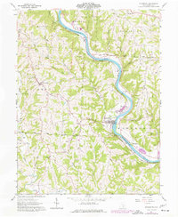
1961 Map of Stockport
USGS Topo · Published 1977About this map
The Muskingum River dominates this mid-century portrait of Morgan County, tracing a sweeping oxbow as it flows south past Stockport and the riverfront hamlet of Hooksburg. Along the western bank, the Baltimore and Ohio Railroad follows the water's edge, highlighting the valley's role as a vital transportation corridor. The map preserves the locations of several community foundations, including the County Infirmary and its associated Infirmary Cem, alongside numerous country churches like Hopewell Ch and the Brick Church.
Find a feature on this map
54 named features on this map. Tap any name to fly to it.
Don’t see what you’re looking for? This feature index may not catch every label — zoom into the map to look around manually.
Map Details
Editions of this 1961 Stockport Map
3 editions found
Other maps of this area

1902 · Parkersburg
USGS Topo · 1:62,500

1904 · Parkersburg
USGS Topo · 1:62,500

1904 · Chesterhill
USGS Topo · 1:62,500

1906 · Chesterhill
USGS Topo · 1:62,500

1909 · Caldwell
USGS Topo · 1:62,500

1910 · Mc Connelsville
USGS Topo · 1:62,500

1912 · Caldwell
USGS Topo · 1:62,500

1949 · Clarksburg
USGS Topo · 1:250,000

1956 · Clarksburg
USGS Topo · 1:250,000

1960 · Watertown
USGS Topo · 1:24,000